An Introduction to Remote Sensing for Ecologists Using Google Earth Engine
A successful ecologist is adept at incorporating methods and resources from many fields of study into their own research questions. Remotely sensed data are becoming an increasingly common resource in ecology because of the ability to use imagery to ask questions at the landscape scale.
Below you will find links to learning modules that provide up-to-date and easily accessible lessons in remote sensing using Google Earth Engine that were developed by researchers in the Evangelista Lab specifically for ecologists in the GDPE community. Each HTML webpage will introduce the topics to be covered, review background information on the utilized concepts, and provide a demonstration of how to integrate remote sensing, ecology, and Google Earth Engine tools. The goal of these modules is to provide some basic understanding of remote sensing principles with ecological applications using the Google Earth Engine platform.
These modules cover some of the core concepts in remote sensing but should not be considered a full introduction to remote sensing. CSU offers more comprehensive and structured courses on this material (i.e. NR 503 & 504). In addition, while these 10 modules will cover much of the functionality and capabilities of Google Earth Engine, there remains a wealth of knowledge and expanded tutorial data on the official user guide here. It is highly recommended to bookmark and utilize this resource to help answer technical questions outside the scope of the modules.
Finally, discussion and troubleshooting are encouraged among peers and colleagues on the official GDPE Google Earth Engine Google Group forum. Click here to request access.
Module 1: Introduction to Google Earth Engine
Get acquainted with the user interface and visualize image differences before and after the High Park Fire.
Module 2: Exploring Datasets
Briefly overview numerous spatial datasets and associated metadata using the MODIS Snow Cover dataset.
Module 3: Raster Interpretation and Visualization
Use visualization methods to interpret Landsat and NLCD data over Montreal and Washington state.
Module 4: Moving Data In and Out of Google Earth Engine
Integrate daily weather data with GPS locations from a cougar to analyze how weather affects the cat’s movement.
Module 5: Raster Pre-Processing
Review dataset processing levels and perform cloudmasking over Quetico Provincial Park in southwest Ontario, Canada.
Module 6: Spectral Indices
Use crop data to identify remote sensing indices that can highlight irrigated lands in arid regions.
Module 7: Image Classification
Generate predictions of aspen presence and absence in western Colorado using the randomForest algorithm and Landsat data.
Module 8: Multi-temporal Analysis
Conduct a time series analysis to determine the effect of the Deep Water Horizon oil spill on algal productivity in the Gulf of Mexico.
Module 9: Ocular Sampling
Use remote sensing data to generate a set of potential sampling sites for a study on Elk herbivory.
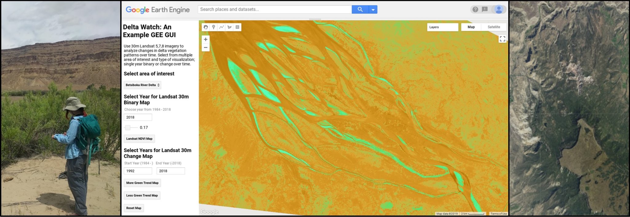
Module 10: GUI Development
Build a graphical user interface that lets users view changes in vegetation over time for three major river deltas across the world.
Any use of trade, products, or firm names is for descriptive purposes only and does not imply endorsement by Colorado State University or any other collaborating individuals or agency. These modules were created for educational purposes and the data presented in these lessons may be incomplete or inaccurate.